Napa Valley...by car

Tuesday, Dec. 14, 2010
No bicycle riding today!

Being at the back (cellar) door of Napa Valley, Angelo offered to take me down into the valley to see the renowned area, visit a few wineries and do some tasting. Okay, twist my arm.

The weather wasn't the best––alternately drizzly and rainy––but Angelo knows the area intimately and took me around to some of the different towns and appellations, discussing each of the wineries, some of the history of the area, a bit about some of the world-class restaurants, including The French Laundry (Occasionally rated best restaurant in the world by esteemed culinary publications.), and stopping at Joseph Phelps Winery for tastings of their top wines. Their 2007 Insignia was the most expensive wine I'd ever tasted ($225/bottle), but to my unrefined palate didn't taste $213 better than a pedestrian wine I'd purchase from Columbia Crest or Chateau Ste Michelle. Maybe I just need to do more wine tasting!?

Being in the Napa Valley and, I suppose, needing to differentiate themselves from the fold, some wineries turn to exuberant architecture and art in an effort to attract the crowds. (What does this say about the quality of their wine?) Artesa, with its bunker-like architecture, is one of those wineries:

After lunch at a great little Mexican place, Angelo then mentioned, almost like an afterthought, that there was a winery he'd show me that was designed by an interesting Viennese artist...

I interrupted, "Hundertwasser?"

Angelo looked surprised. "You know of him?"

Know of him? He's a favorite of mine and I didn't realize there was a building here that he'd designed! (In fact, it's the only Hundertwasser design in the U.S.)

When I was in Vienna back in 1997 I'd stumbled across Hundertwasserhaus, an apartment building which, having previously only done visual art, marked Hunderwasser's foray into architecture. I was blown away by it and it really stayed with me, so when Angelo said we'd visit a winery that was designed by Hundertwasser, I was elated.

Photos can't capture it, but I tried:


The City by the Bay!

Monday, Dec. 13, 2010
This morning I put some flowers in my hair and left San Geronimo for San Francisco.

Just north of the city on the west side of the Bay is a string of $wanky communities that all look alike and run together: Fairfax, San Anselmo, Ross, Kentfield, Larkspur, Corte Madera, Mill Valley, Marin City, Sausalito. Here're a few photos from along this stretch:


There's a nice bike path that runs alongside Hwy 101 from Mill Valley into Sausalito. I shot this video somewhere between Mill Valley and Marin City:


And then!:


This really felt like the second big destination. (The first being the 'Welcome to California' sign.) Here I am looking pleased (Or proud? Maybe smug? Relieved?):

I mounted my camera to the rack on the front of my bike and recorded the ride across the 'Gate. Problem is, every little bump, crack and vibration is amplified in the camera. It's not as bumpy as it looks:


It's one thing to drive across the Golden Gate, but if you ever get a chance to walk or ride across it, I highly recommend it––it's quite amazing. (And you can't beat the price!) Here're a couple of photos taken on the walk/bikeway:


Once on the opposite (south) side, I shot these photos:


I had an offer from Steve's dad (Steve is my sister Amy's "squeeze."), Angelo, in Vallejo for accommodations, so from downtown I was to catch the ferry to Vallejo which is at the north-northeast end of the bay. The Bay is so large that the ferry, a high-speed catamaran, takes an hour to get there! Here's what the ferry looks like:

From the Presidio at the south end of the Golden Gate, I meandered through the city, staying near the water so as to avoid the city's notorious hills, working my way toward the Ferry Plaza to catch the 5:15 to Vallejo.

I had decided that while in San Francisco I would photograph the SF stereotypes, so on my way to the ferry I captured a few:

The Marina District:


The Ghirardelli sign:

Alcatraz:

A cable car:

The Ferry Building:

Inside the Ferry Building is the Marketplace:

Snapped these as the ferry was departing:


Angelo isn't really in Vallejo proper but up in the hills northeast of Vallejo in a newer development called Hiddenbrook. It took me a while to get from the ferry to his house, but Angelo was very gracious and had a wonderful pasta dinner waiting for me when I arrived.

The problem with doing a trip like this is how much food one can/needs to consume after bicycling all day. When invited into someone's home for dinner it's embarrassing and/or potentially obnoxious when asking for third, fourth, even fifth servings. Sometimes I'll have rations stored in my panniers that I can eat later in private if dinner––for whatever reason––proves unfulfilling. Fortunately I haven't yet had to resort to clandestine calorie consumption.

Angelo has a grand piano as well as a very nice electronic piano and I asked him if he wouldn't mind playing. I recorded him playing music from West Side Story, edited down here:

Bodega Bay to San Geronimo

Sunday, Dec. 12, 2010
Passed this restaurant in the town of Valley Ford:
I wonder what kind of food they serve?

Highway 1 passes through the wee town of Tomales. Here's the general store:

And a panorama of a couple local businesses:

I've been surprised at the number of little communities like this. Many of them have very nice little bakeries/delis/coffee shops that serve as the town gathering spot. Today being a Sunday with decent weather there were a whole lot of both bicyclists and motorcyclists out. This was Tomales' bakery/deli/coffee shop gathering spot across the street from the general store:

Down the street was the church (Catholic, naturally):

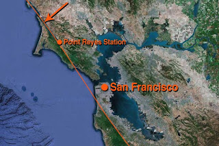
North of the town Point Reyes Station, Highway 1 runs alongside Tomales Bay which was formed by the infamous San Andreas fault. The S.A. fault runs underneath the water here (left to right):

The arrow on this Google Maps satellite view of the Bay Area points to the spot where the above photo was taken. The thin line is where the San Andreas fault lies:

Over the last one or two hundred miles the flora has really started to change. We're definitely not in the Pacific NW anymore:

Road signs entering the town of Marshall, population 50:

There are a lot of these "Share the Road" signs:
(Notice the Ferrari 208? Very California!)

California is much more bike friendly and aware than I expected. (Maybe it's just Northern California?) Many more local cyclists than I'd've thought and car/truck drivers are much more courteous and accepting than I'd expected. Pleasantly surprised.

This is downtown Point Reyes Station:

Again, lots of bicyclists, congregating at the local bakery/coffee shop. If you find yourself in this area, don't miss Bovine Bakery (In the photo it's the place to the left of Viewpoints.) in Point Reyes Station. This is a very popular destination for cyclists from San Francisco as it's about 35-40 miles from the city and there aren't any brutal hills in between.

Yesterday I had connected with a warmshowers.org host in Point Reyes Station, but had said I'd thought I'd blow through Point Reyes and be quite a ways further south by Sunday evening. Alas, I ended up taking more time than I'd expected getting here and by 3:30PM was ready to call it a day. I called the warmshowers guy but couldn't reach him. So, not knowing where I'd stay, I pedaled toward Olema. The man at the front desk of a B&B which was way out of my price range was very friendly and offered to call the Two Birds Inn in San Geronimo to see what they could do. It was about an hour away but was much cheaper than the B&B and was the only option in the area. So off I went, figuring I could always camp somewhere if I found a suitable spot along the way.

Not having seen an adequate spot to pitch camp (The area was alternately hilly with thick vegetation, swampy/wet, or private, posted "No Trespassing" land.), I arrived at the Two Birds Inn and Cafe just after dark.

Chatting with a couple of the employees, I learned that the cafe has live music on the weekends and tonight a few musicians were coming in to play. They suggested I come back to the cafe in about an hour.

The room was bare-bones with no television or internet access, so I had no excuse for not checking out the evening's live entertainment. I found the cafe more crowded than I'd expected and the caliber of the music quite a bit better than I'd expected. It was a jazz ensemble with a few locals taking turns sitting in on piano and/or microphone. I recorded the hodge-podge group doing an 8-minute version of "Moondance," cut down here to about 30 seconds:

While still passive, it was much better entertainment than turning on the TV and channel surfing through a bunch of crap.

Of course, I suppose I also could've been working on getting caught up on this dagnabbed blog!

Gualala to Bodega Bay

Saturday, Dec. 11, 2010
Leaving Gualala, took these two photos of the Surf Motel:

Just a few minutes down the road and who do I see up ahead? Franklin from Bellingham:

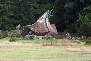
Again, we ride together for a bit. Passed a very unusual house that reminded me of a wizard's hat:
[Edit: Ron from Fort Bragg informs me this is not a house but a church or chapel.]

Lots of livestock––mainly cattle, sheep and goats––along the way:


Came across this general store in Stewarts Point:

Built in 1868. (100 years before I was born.)

Here's a panoramic view of the interior (The shelves in the far left of the photo are facing the shelves in the far right.):

The owner of the store told me the population of Stewarts Point is three. They live next to the general store in this house that was built at the same time:

After leaving Stewarts Point, I was again back into thick, wet fog for most of the remainder of the day. Here's a view of what Highway 1 typically looks like along this stretch:

I think I passed a lot of scenery today which wasn't visible due to the thick vapor. Every so often the road would descend and I'd catch a glimpse of the water and rocks:

Or one of the ubiquitous turkey vultures attempting (in this fog, unsuccessfully) to dry its wings:

Stopped for a rest at this little market in Ocean Cove:

The landscape here alternates between grassy, windswept, rocky hills fronting the ocean and thickets of trees/forest, usually inland a few hundred yards or more from the shoreline. Stopped in one of the forest thickets to get a photo of the sunlight streaming through and noticed spiderwebs on this plant (hemlock?):

Passed another interesting house:

Stopped in Bodega Bay at Doran City Park campground. Pitched camp:

Amazingly, if you zoom in on Google Maps, you can see the spot. Search for Bodega Bay in Google Maps, then start zooming in where the arrow is pointing:

You'll find the campsite with the fire pit/barrel thing and the picnic table (I made a circle and rectangle to mark the fire pit and table.):
Cool!

Met two other Bay Area residents (They weren't together.) who were camping nearby; Adrian, a young guy who was camping around, killing time before going to work on a farm in Petaluma, and Nicole, a 20-something who'd been out day-hiking with friends and had decided to camp in Bodega Bay instead of going home. The three of us sat around the fire at my campsite and talked. Adrian had a guitar with him, so he added ambiance for a while. If it all sounds enchanting and groovy, it wasn't. The air was slightly cold and thick with water vapor/fog, the conversation wasn't inspired or interesting, and the guitar playing (noodling) quickly became tiresome. Eventually I told them I needed to hit the sack and they left.